Images show Israel building permanent military bases in Gaza as US-backed reconstruction plans stall.
The United States has proposed plans to rebuild Rafah, a city in southern Gaza that was flattened by two years of Israeli bombardment. It has been touted as the centrepiece of a US-Israeli vision for a post-war Gaza, but satellite images suggest the project has stalled before even breaking ground.
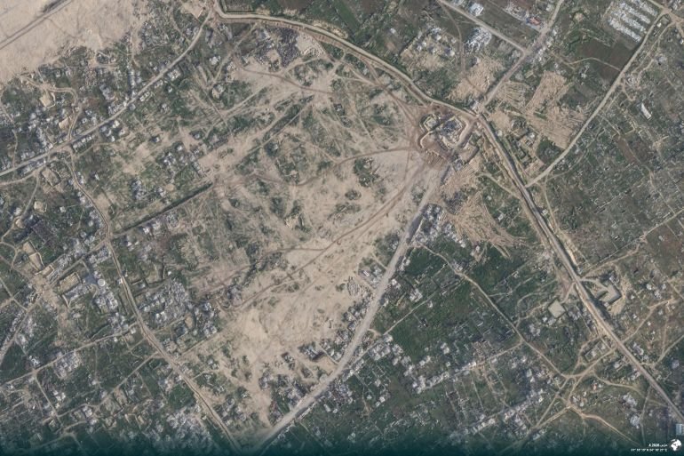
An Al Jazeera Digital Investigations Unit examination of Planet Labs and Sentinel Hub satellite imagery revealed that Israeli military fortifications are expanding at a relentless pace across Gaza, particularly in Rafah.
Recommended Stories
list of 4 itemsend of list
Analysis of imagery from February 25 to March 15 confirmed that while rubble removal has essentially ceased in Beit Hanoon in the north and Rafah, Israeli forces are systematically entrenching a permanent military reality across the devastated enclave.
While civilian reconstruction has slowed, Israeli military construction has accelerated. Satellite imagery from March 10 shows extensive clearing and fortification at the strategic al-Muntar hilltop in Shujayea, a neighbourhood in Gaza City, and outposts in Khan Younis in Gaza’s south.
In central Gaza, Sentinel imagery from March 15 revealed ongoing work on a trench and dirt berm reaching as far as the Maghazi camp near Deir el-Balah. In Juhor ad-Dik, new roads now link established military sites to newly levelled areas, suggesting the creation of permanent outposts.
These findings align with a late 2025 investigation by Forensic Architecture that identified 48 Israeli military sites within Gaza – 13 of which were built after an October “ceasefire”. These sites have evolved into permanent bases with paved roads, watchtowers and constant communication links to Israel’s domestic military network.
![Satellite images captured between February 20 and March 10, 2026, reveal significant engineering and expansion works at an Israeli military outpost east of Gaza City. [Al Jazeera/Planet]](https://www.aljazeera.com/wp-content/uploads/2026/04/INTERACTIVE-East-of-Gaza-City-1776591210.png?quality=80)
The ‘New Rafah’ illusion
At the World Economic Forum in the Swiss city of Davos in January, Jared Kushner, US President Donald Trump’s son-in-law, showcased AI-generated visions of a “New Rafah” featuring skyscrapers and luxury resorts. Trump further promoted this “Middle East Riviera” through a 20-point plan, promising $10bn in funding via the Board of Peace, which he has established as a potential rival of the United Nations.
However, the Geneva-based Euro-Med Human Rights Monitor has warned that the “New Rafah” plan is a mechanism for demographic re-engineering and forced displacement.
The plan involves dividing Gaza into population blocks and closed military zones. Palestinians would be confined to “cities” of residential caravans, each packing roughly 25,000 people into a single square kilometre (0.4sq miles). These “cities” are to be surrounded by fences and checkpoints, and access to essential services would be contingent upon passing Israeli-US security screenings – a model Euro-Med likened to ghettos.
![An Israeli military site in Khan Younis, southern Gaza, shows continuous development, paving, and fortification in March 2026. [Planet laba]](https://www.aljazeera.com/wp-content/uploads/2026/04/%D8%B5%D9%88%D8%B1%D8%A9-10-copy-1776587292.jpg?w=770&resize=770%2C433&quality=80)
A new, permanent border
Gaza’s “yellow line” “ceasefire” boundary is being transformed into a permanent frontier. In Beit Lahiya in the north, satellite images from March 4 show the construction of a dirt berm along the “yellow line” and another running parallel to it and constructed more than 580 metres (634 yards) into what the “ceasefire” designates as land where Palestinians are supposed to live – a significant encroachment beyond the designated line.
In December, Israeli Chief of Staff Eyal Zamir defined the line as a “new border”. Defence Minister Israel Katz later declared Israel would “never leave Gaza”, promising to establish military-agricultural settlements.
Al Jazeera’s investigation further documented that Israel has secretly moved concrete boundary markers hundreds of metres deeper into areas designated for Palestinians.
![Traces of Israeli military vehicles are seen operating beyond the designated dirt berm in northern Gaza on March 10, 2026, in clear violation of ceasefire demarcations. [Al Jazeera/Sentinel Hub]](https://www.aljazeera.com/wp-content/uploads/2026/04/INTERACTIVE-Gaza-Deir-el-Balah-1776591213.png?quality=80)
A bloody ‘ceasefire’
Despite the October “ceasefire”, violence persists. Gaza’s Ministry of Health reported 750 deaths and more than 2,090 injuries since the “ceasefire” began, bringing the total death toll since the October 2023 start of Israel’s genocidal war to more than 72,300. An independent study in The Lancet medical journal suggested the actual death toll could be significantly higher. It estimated more than 75,000 deaths from “direct violence” by early 2025 alone.
An Al Jazeera analysis found that Israel has launched attacks on 160 out of the 182 days of the “ceasefire”. These attacks often involve incursions aimed at levelling areas designated for Palestinian habitation.
Efforts to document these developments are facing unprecedented hurdles. This month, Planet Labs announced an “indefinite” ban on images from conflict zones after a US government request. Other providers, like Vantor, have imposed similar restrictions, severely limiting the ability of media and human rights groups to monitor the situation in Gaza.
As of this month, humanitarian assessments by aid groups, including Oxfam and Save the Children, have given the Trump reconstruction plan a failing grade, saying it has failed to “demonstrate a clear impact on conditions inside Gaza”.

Leave a Reply